
From Orbit to Farmland: How Space Technology—and NASA Harvest—Are Reshaping Global Agriculture
The 2025 joint publication by the United Nations Office for Outer Space Affairs (UNOOSA) and the Food and Agriculture Organization (FAO), “Leveraging Space Technology for Agricultural Development and Food Security,” outlines a powerful vision: using space-based technologies to tackle one of the world’s most urgent challenges—food supply insecurity.
This report offers a comprehensive blueprint for how space-based technologies can revolutionize global agriculture amid escalating food insecurity driven by climate change, resource limitations, population growth, and geopolitical disruptions.
Structured around the space technology value chain, the report examines three interconnected segments—upstream, midstream, and downstream—that describe the full journey from satellite infrastructure to actionable insights for farmers and policymakers.
Upstream: Building the Space Backbone
The upstream segment focuses on the satellites themselves—Earth observation missions like Landsat and Copernicus, and GNSS (Global Navigation Satellite Systems) that provide precise geographic data. These platforms generate high-resolution imagery and positioning data essential for modern agricultural tasks such as crop monitoring, irrigation planning, and pest management. As satellite technology evolves, incorporating features like hyperspectral imaging and SAR (synthetic aperture radar), its utility for precision agriculture grows exponentially.
Midstream: Managing the Data
At the midstream stage, the focus shifts to data processing and infrastructure. Emphasis is placed on spatial data infrastructures (SDIs), frameworks like the UN Integrated Geospatial Information Framework (UN-IGIF), and standards that ensure geospatial data is accurate, accessible, and interoperable across regions. Effective data management is critical to turning raw satellite feeds into insights that can drive agricultural decisions.
Downstream: Real-World Agricultural Applications
The downstream segment is where the impact is felt most tangibly—where data meets dirt. Here, the report highlights platforms like the FAO’s Hand-in-Hand Geospatial Platform, which provides over two million layers of open-access geospatial data to stakeholders around the globe.
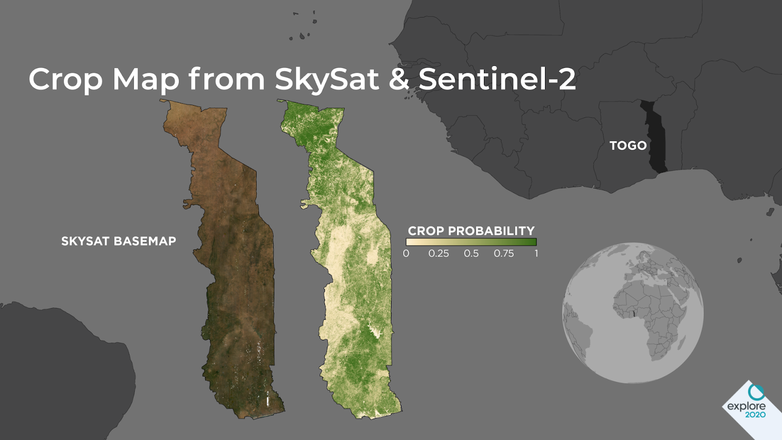
Among the most compelling downstream examples is NASA Harvest, NASA’s International Food Supply and Agriculture Consortium. The report cites a case study from Togo, where NASA Harvest, in partnership with Planet Labs and the University of Maryland, deployed satellite-based crop monitoring tools in response to the COVID-19 pandemic. Using machine learning to analyze imagery from the European Space Agency’s Sentinel-2, NASA’s Landsat, and Planet’s SkySat, NASA Harvest was able to generate rapid, reliable crop maps without needing ground-truth data—a crucial innovation when mobility was restricted.
These maps enabled the Togolese government to swiftly roll out food relief programs. The initiative demonstrates not only the utility of space data during crises but also the value of international, multi-sector partnerships that combine public institutions, academia, and private enterprise.
A Vision for the Future
The publication concludes with a call to action: enhance global coordination, build inclusve geospatial capacities, and ensure that the benefits of space technology are equitably distributed. It urges decision-makers to invest in Earth observation infrastructure, promote data sharing, and strengthen the integration of space tools into national agricultural strategies.
As the world confronts mounting environmental and humanitarian challenges, this report shows that the future of agriculture lies not just in the soil—but also far above it.
You can read the original report in its entirety here.