
Satellite Data Reveals Where Ukrainian Farmland Has Been Abandoned and Reclaimed
Since Russia’s invasion of Ukraine in 2022, NASA Harvest researchers have used satellite data to track how the war is affecting one of the world’s major agricultural producers. That work has included mapping field boundaries and crop types, forecasting yields, and assessing damage to agricultural production. We’re continuing to build on that research with a new study tracking where cropland has remained in production, where it has been left fallow or abandoned, and where previously abandoned fields are returning to use.
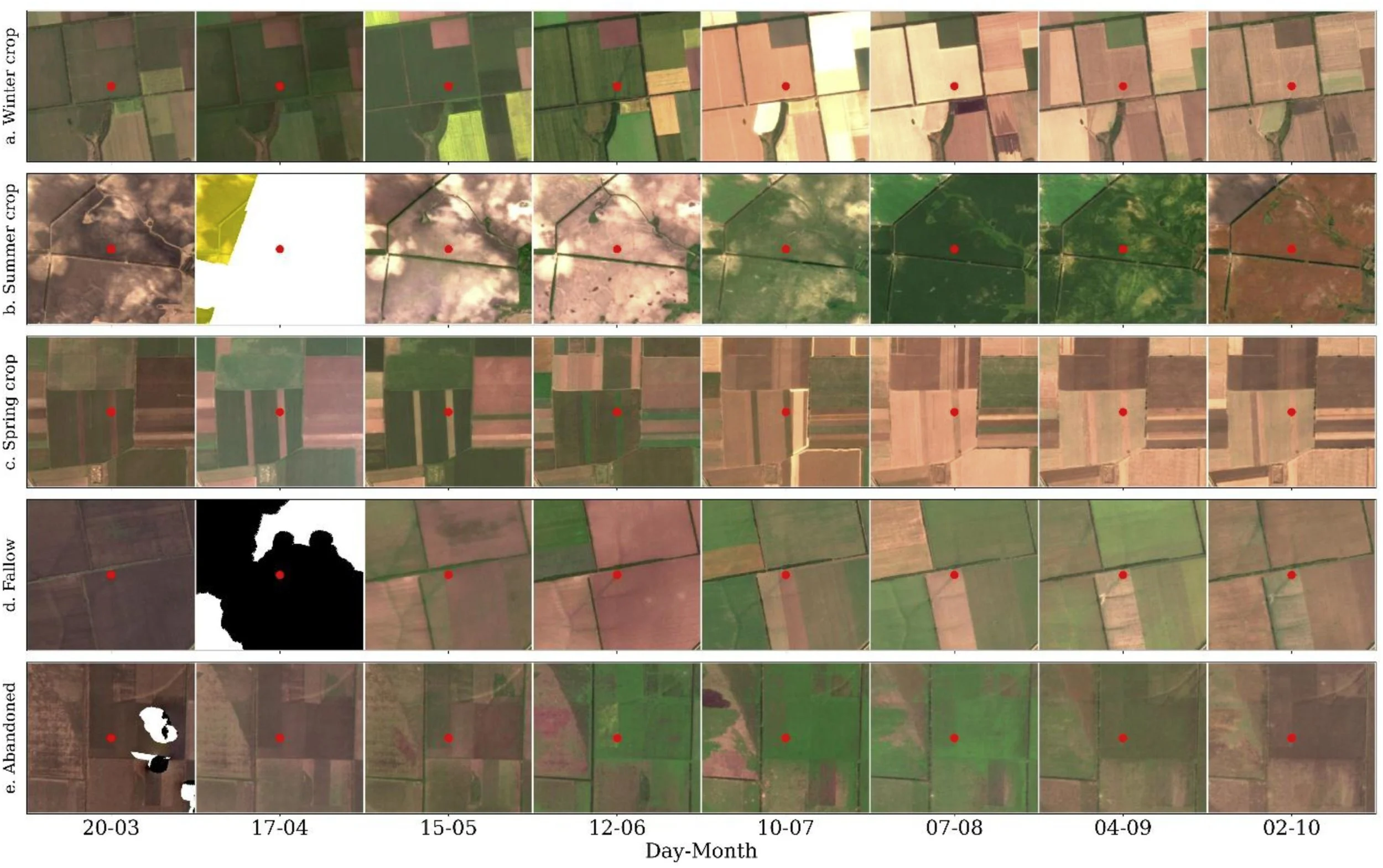
Satellite images show how researchers distinguished cultivated, fallow, and abandoned cropland over the course of a growing season. Crop growth and harvest patterns identify actively cultivated fields, while signs of tillage can distinguish managed fallow land from abandoned fields with no visible farmer intervention. The red dots mark the locations being evaluated.
Previous studies have produced widely different estimates of how much Ukrainian cropland has been abandoned during the war, with some estimates varying by as much as fourfold. Part of that difference comes from how abandoned land is defined. Fields left fallow may go a full season without producing a crop while farmers still plow, control weeds, or otherwise manage the land. Abandoned fields show no signs of management. In areas affected by fighting, they may also be difficult or unsafe to return to because of mine, unexploded ordnance, shell damage, or other contamination. Grouping the two together can inflate estimates of cropland abandonment and make it harder to determine which land could return to production and which may require more extensive recovery efforts.
How the Team Tracked Change
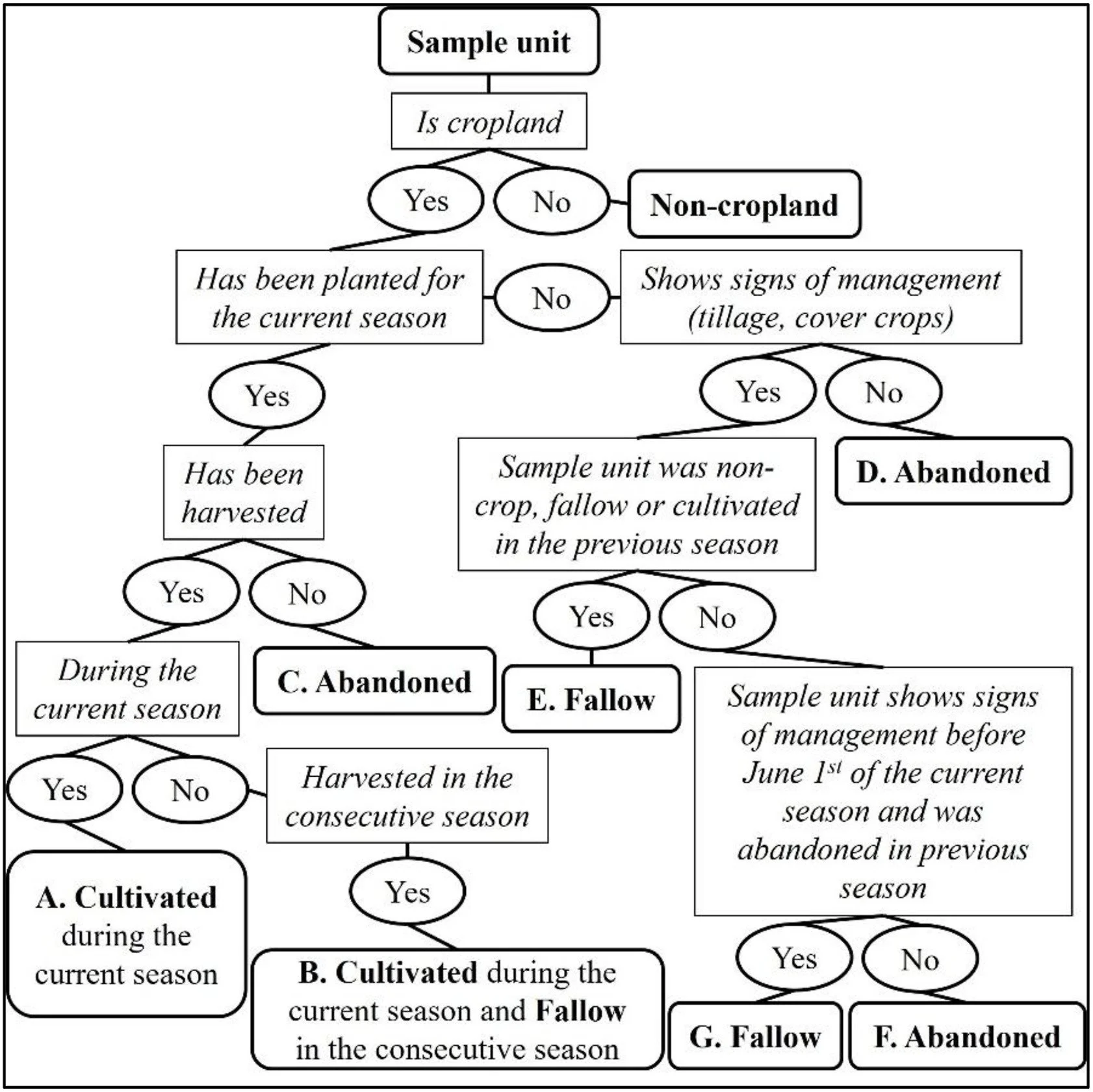
Researchers used a decision process to classify sampled fields based on signs of crop growth, harvest, and other management. Fields showing crop growth and harvest were classified as cultivated, while fields without a harvest were identified as fallow or abandoned depending on whether analysts could detect signs of continued management.
To separate those categories, researchers followed the same sampled locations from 2021 through 2024 using high-resolution satellite imagery. They looked for signs of planting, harvest, tillage, weed control, and other field management, then paired those observations with information on conflict events, shifting frontlines, and artillery craters to compare how farmland changed under different levels of fighting. Finally, experienced analysts reviewed imagery across each growing season helping distinguish fields that had stopped being managed from those that were intentionally left fallow.
The team also avoided estimating acreage by simply counting every pixel classified as cultivated or non-cultivated in a satellite-derived map. Classification errors in a satellite map can carry directly into those totals. Instead, the map was used to guide a random stratified sample, and expert interpretation of those sampled locations was used to estimate cultivated, fallow, and abandoned acreage separately and report the uncertainty around each estimate. That approach also allowed the researchers to separate fallow and abandoned land even though the initial satellite map grouped both as non-cultivated.
What the Study Found
The results show a clear decline in active cultivation since the start of the war. Across Ukraine, cultivated cropland fell from 29.7 million hectares in 2021 to 27.1 million hectares in 2024, an 8.5 percent decline. By 2024, researchers estimated that 1.8 million hectares were fallow and 2.2 million hectares had been abandoned. The latter figure includes land that may still return to production, so the study also examined how long fields had remained unmanaged. Based on fields abandoned across multiple growing seasons, the team estimates that roughly 1.1 to 1.7 million hectares may face longer-term abandonment.
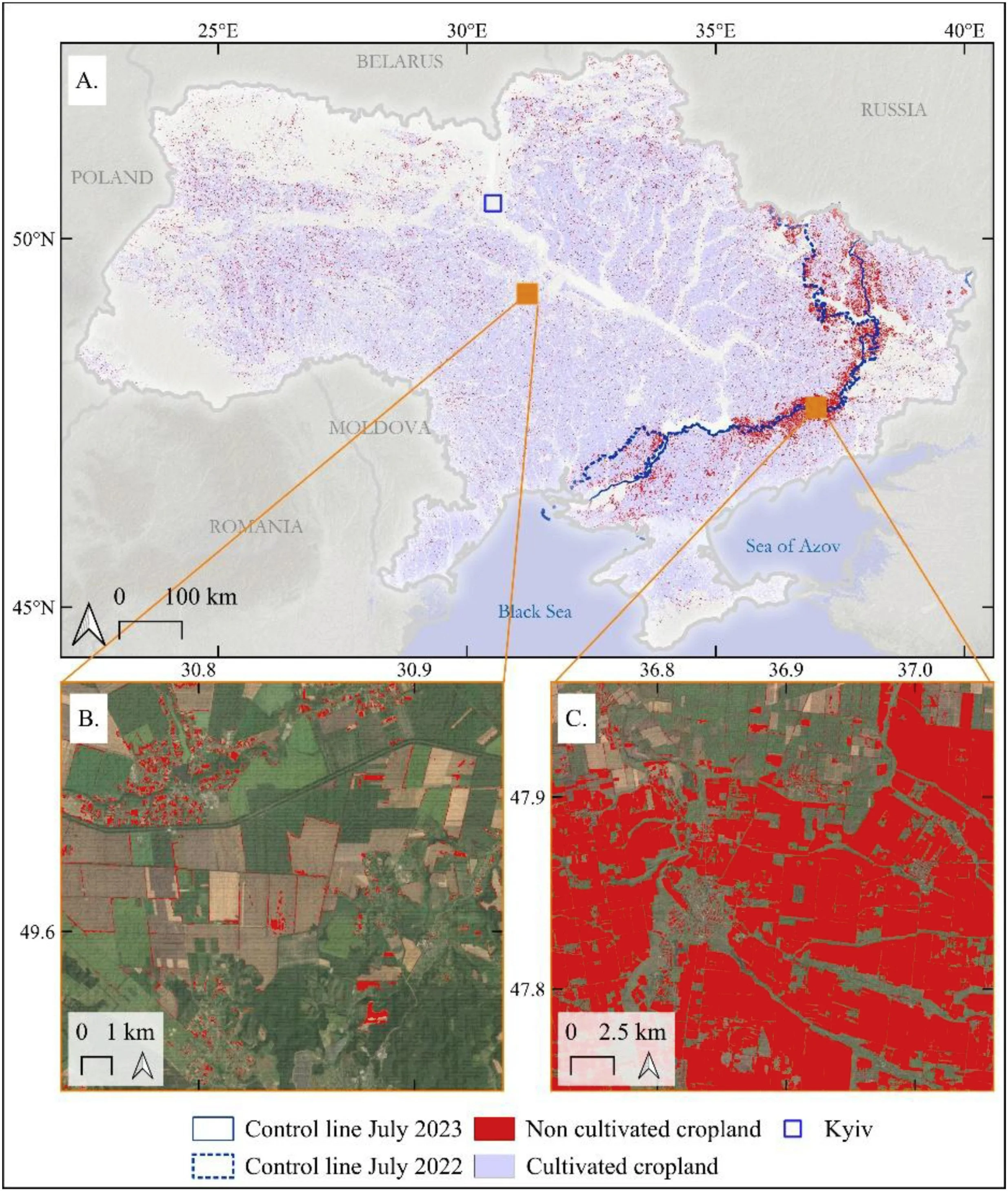
The 2023 cultivation map shows how non-cultivated cropland was concentrated near the frontlines. The national map (A) is paired with examples from an area far from the front (B) and along the 2022–2023 frontline (C), where large areas of cropland were no longer being cultivated. At this mapping stage, fallow and abandoned fields were grouped together as non-cultivated cropland.
Predictably, the losses were concentrated in areas closer to the frontlines rather than spread evenly across Ukraine. In areas exposed to sustained fighting, cultivation dropped sharply and abandonment remained high. Fields closer to the frontlines, in places with more conflict events, and in areas with denser artillery cratering, were more likely to be abandoned and less likely to return to management. Where fighting receded, the pattern began to reverse, with abandoned acreage declining and cultivation starting to recover, particularly in territory retaken by Ukrainian forces.
The study also found that some abandoned farmland is returning to use. The team estimates that about 296,000 hectares were brought back into management in 2023, followed by another 472,000 hectares in 2024. Most of that recovery occurred in areas where fighting had receded, particularly in southern Ukraine. In some cases, fields moved from abandonment to fallow before returning to active cultivation, showing that recovery can happen gradually rather than in a single season.
The scale of that recovery raises questions about how some of these fields are being made safe enough to farm again. Ukraine’s Ministry of Economy reported that 285,000 hectares of cropland were declared safe for recultivation in 2024, while the study found that about 472,000 hectares of previously abandoned land returned to management that year. The authors suggest that some of the difference may reflect informal or farmer-led demining, although the satellite analysis cannot determine how individual fields were cleared. Tracking where land returns to use could help authorities and demining organizations avoid duplicating work and focus resources on areas that remain abandoned.
Remote sensing makes this kind of monitoring possible even where field access remains unsafe or impossible. Combined with expert interpretation and sample-based estimates, it can provide more than a measure of wartime agricultural losses. The same approach can help track recovery, inform farmer support and tax relief, and prioritize demining, and identify where bringing farmland back into production may require longer-term investment.
The original article was published in Science of Remote Sensing and can be read for free here.