
Why Ukraine’s 2025 Harvest Matters and How NASA Harvest is Measuring It from Space
As the war in Ukraine continues, the world’s food supply remains at risk.
NASA Harvest, NASA’s food supply and agriculture program, has released its 2025 winter crop production estimates for Ukraine, using satellite data to monitor fields that many can no longer safely visit. These new estimates show that Ukraine’s government-controlled areas are expected to produce around 21 million metric tons (MMT) of winter wheat and 4 MMT of rapeseed, while Russian-occupied territories will produce around 5 MMT of wheat and 0.12 MMT of rapeseed.
Why does this matter to people living far from the frontlines, including here in the United States?

NASA Harvest production estimates show comparisons of crop production (wheat, top; rapeseed, bottom) over time, by occupation status, and in reference to the USDA 4-year average estimates. Overall, estimates show a slight decrease in crop productivity in 2025 compared to last year, mostly driven by a slight reduction in planted areas. (Data provided by Planet) (Measurements and charts developed by NASA Harvest’s Wagner J., Kalecinski N., Kotcharlakota A., Gupta M., Becker-Reshef I.).
Because global food security is deeply interconnected. Ukraine is a major producer of wheat and other grains, exporting to regions across Africa, the Middle East, and parts of Asia where food insecurity is already high. Disruptions in Ukraine’s harvests can lead to higher global grain prices, which ripple through the supply chain, raising the cost of bread, pasta, and animal feed worldwide. When prices spike globally, they also add strain to humanitarian efforts to deliver food aid where it is most needed.
Agricultural monitoring under conflict conditions is challenging, but satellite data can “see” crops from space, providing critical, unbiased information even when ground access is limited or too dangerous. By tracking crop conditions, planting, and harvests across both occupied and government-controlled regions, NASA Harvest helps governments, humanitarian agencies, and markets anticipate food supply shocks before they spiral into crises.
This work is not just about numbers on a page; it is about keeping food affordable and available for families around the world and reducing the chance that conflicts spill over into food riots, migration crises, and political instability.
As extreme weather, conflicts, and trade disruptions continue to threaten global food systems, tools like satellite-based crop monitoring are proving essential in helping the world prepare for shocks and in reminding us all that what grows in Ukraine’s fields touches dinner tables far beyond its borders.
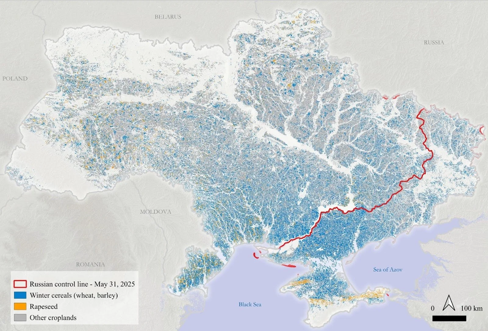
NASA Harvest winter crops map for season 2025 in Ukraine. The map is based on publicly available Sentinel-2 and Sentinel-1 satellite imagery. The frontline is provided by the Institute for the Study of War and AEI's Critical Threats Project.
A significant portion of the 2025 estimates were made possible through the dedicated contributions of Ukrainian agricultural producers, including Kernel, IMC, and Nibulon, as well as service providers such as Frendt. Data from Kernel, IMC, and Frendt have been integral to NASA Harvest’s research since the outset of the war, fostering long-term collaboration and strengthening our joint efforts. A newly established partnership with Nibulon—particularly data from its Mykolaiv cluster located near the frontline—has provided critical insights into some of the most challenging areas to monitor.