
Bringing Clarity to Crop Cycles: How Data Fusion is Advancing Smallholder Agriculture in Egypt

Wide view of the Nile River and Suez Canal, Egypt, as photographed with a digital still camera aboard the International Space Station. Credit: NASA
In Egypt’s fertile Nile Delta, smallholder farmers cultivate fields of wheat, maize, rice, and clover in tight rotation. These fields, often less than two hectares in size, form the backbone of national food production. But for scientists and policymakers alike, tracking when crops are planted and harvested across thousands of fragmented plots has always been a major challenge. Now, a new study co-authored by NASA Harvest researchers and partners is helping to close that gap with a novel approach to satellite data fusion.
The study, titled Retrieving crop phenology at field-scale in the Nile Delta based on Sen2Like and PlanetScope data, explores how combining freely available imagery from Sentinel-2 and Landsat satellites can improve our understanding of crop growth at the field level. Using a data-processing tool called Sen2Like, the research team produced a harmonized, high-resolution image dataset that can more frequently capture key agricultural changes, even during cloudy periods when typical satellite systems might miss a season entirely.
“This kind of detailed, field-level insight has traditionally been out of reach for many smallholder regions,” said Belen Franch, Crop Yield Co-Lead at NASA Harvest and professor at the University of Valencia. “By fusing satellite datasets that are already available to the public, we’ve created a cost-effective way to monitor crops in places where food security is closely tied to small-scale farming.”
To test their method, the researchers analyzed six years of crop cycles across 42 fields in Egypt’s El Gharbia Governorate. The fused data allowed them to pinpoint the start and end of growing seasons with high accuracy. In fact, the team was able to detect 91 percent of crop cycles, outperforming imagery from Sentinel-2 alone. They also validated their findings using PlanetScope, a commercial satellite system with near-daily image collection. For spring crops, the differences between the fused data and PlanetScope imagery were often as small as one day.
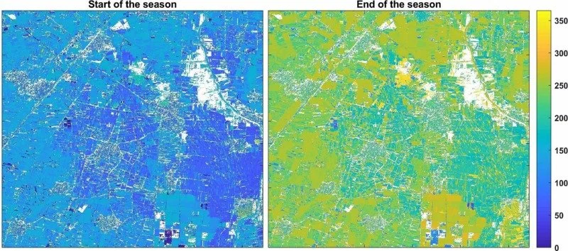
These maps show the start and end of season in the study area. Numbers represent the day of the year (1-365) when the season was first detected to begin or end.
“We wanted to show that it's possible to monitor crops at the scale of individual fields using open-access satellite data,” said Katarzyna Cyran, lead author of the study and a researcher at the University of Valencia. “This approach could be a useful tool for countries that rely heavily on smallholder farming but lack access to expensive data or monitoring systems.”
This technique proved especially valuable for identifying back-to-back crops like clover, where short windows between planting and harvest can make it hard to distinguish one season from another. With more accurate data, governments and development organizations can better anticipate food needs, manage resources, and respond to drought or planting failures.
The study's approach opens the door for broader use in other smallholder-dominated regions facing similar monitoring challenges. As climate pressures increase and agricultural planning becomes more complex, tools like this offer a promising way to bridge the data gap by bringing timely, local-scale information to the people and institutions who need it most.
To read the full article, visit: Retrieving crop phenology at field-scale in the Nile Delta based on Sen2Like and PlanetScope data