
A New Perspective from Space: How Galileo is Advancing NASA Harvest’s Mission to Safeguard Our Planet
Have you ever thought about how scientists keep track of what is happening all over the Earth? Thanks to satellites orbiting high above us, we have eyes in the sky that capture vast amounts of information every day. These satellites monitor everything from sprawling forests and melting glaciers to tiny fishing boats and fields of crops. But turning this endless stream of satellite data into meaningful insights is a big challenge. That is why a team of researchers from NASA Harvest, the Allen Institute for AI (Ai2) and partner organizations set out to create a smarter solution.
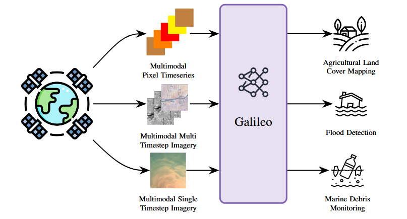
A single Galileo model can be applied to a wide range of remote sensing tasks. We achieve this by training Galileo on the diversity of remote sensing modalities used by practitioners for different applications. In addition, we train Galileo to process views of these modalities used by practitioners, ranging from pixel time series to multi timestep imagery to single timestep imagery.
Their new study, titled "Galileo: Learning Global & Local Features of Many Remote Sensing Modalities," was recently published and brought together experts from across the globe. The team aimed to build a tool that could make better sense of all the different types of satellite data we collect so we can make more informed decisions to protect our world.
Why is this research so important? Because satellites do far more than take pictures from space. They help farmers decide when to plant and harvest crops, track how fast glaciers are disappearing, monitor floods, and even detect marine debris floating in the ocean. However, satellite data comes in many forms, like optical images, radar scans, and climate measurements. Until now, most computer models could only handle one type of data at a time. This meant scientists needed separate systems for each problem.
Enter Galileo. This new artificial intelligence (AI) model was designed to process many kinds of satellite data all at once. Even more impressively, Galileo can detect both large-scale patterns, like glaciers retreating over decades, and tiny, short-lived details, like a fishing boat appearing for just a day. By learning to recognize these patterns across multiple scales and data types, Galileo gives researchers a more complete view of what is happening on Earth.
The team found that Galileo outperformed older models that were specialized for just one kind of data. With Galileo, scientists can now use a single model to tackle a wide range of challenges. These include mapping agricultural land, detecting floods, and monitoring marine pollution. It is a powerful step toward making satellite data more versatile and accessible.

Figure from paper presented by Ai2 at ICML 2025. The team used Galileo to map the amount of live fuel moisture content in areas with high wildfire risk. The above maps show how LFMC in the Santa Monica Mountains and nearby coastal communities varies in the month of August across various years. These maps provide insight which areas are at increased potential wildfire risk.
The Ai2 team contributed to the model’s development and supported large-scale training runs on AI2’s computing cluster. More recently, AI2 demonstrated how Galileo can be applied beyond agriculture by using it to model wildfire risk. At the 2025 ICML TerraBytes Workshop, they presented a study that used Galileo to generate high-resolution maps of live fuel moisture content, a key factor in wildfire prediction. This work highlights Galileo’s flexibility as a tool not only for farming and food systems, but also for addressing a wide range of environmental challenges.
One of the lead researchers on this project is Gabriel Tseng, who works with NASA Harvest and Ai2. “This is a big step forward,” said Gabriel Tseng. “By building a model that understands so many different views of Earth, we’re giving scientists and local communities a powerful new way to protect our food supplies, respond to disasters, and keep an eye on our changing climate.”
What is even more exciting is that the Galileo team made their work open source. This means researchers everywhere can use the model, apply it to their own data, and even help improve it. It opens the door for more collaboration and more discoveries.
At NASA Harvest, we believe innovative tools like Galileo are essential for addressing the planet’s most urgent challenges. By transforming complex satellite data into clear, actionable insights, we are better equipped to care for our farms, protect our oceans, and build a more sustainable future.