
When Russia launched its full-scale invasion of Ukraine in February 2022, much of the country’s winter wheat and rapeseed had already been in the ground for months. Planted the previous fall and normally harvested the following summer, the 2022 winter crop was already well underway as fighting spread across major agricultural regions. That raised an immediate question: how much of the crop would farmers actually be able to harvest?
Getting a reliable answer was becoming much harder. Ukraine is a major producer and exporter of wheat and rapeseed, but the war had disrupted the system used to track those crops. Mandatory agricultural reporting was suspended under martial law, surveys of small producers stopped for security reasons, and data from Russian-controlled territories largely disappeared. NASA Harvest used satellite data to complement Ukraine's official statistics where they were still available and help fill the gaps where traditional reporting could no longer reach.
Mapping Winter Crops During Wartime
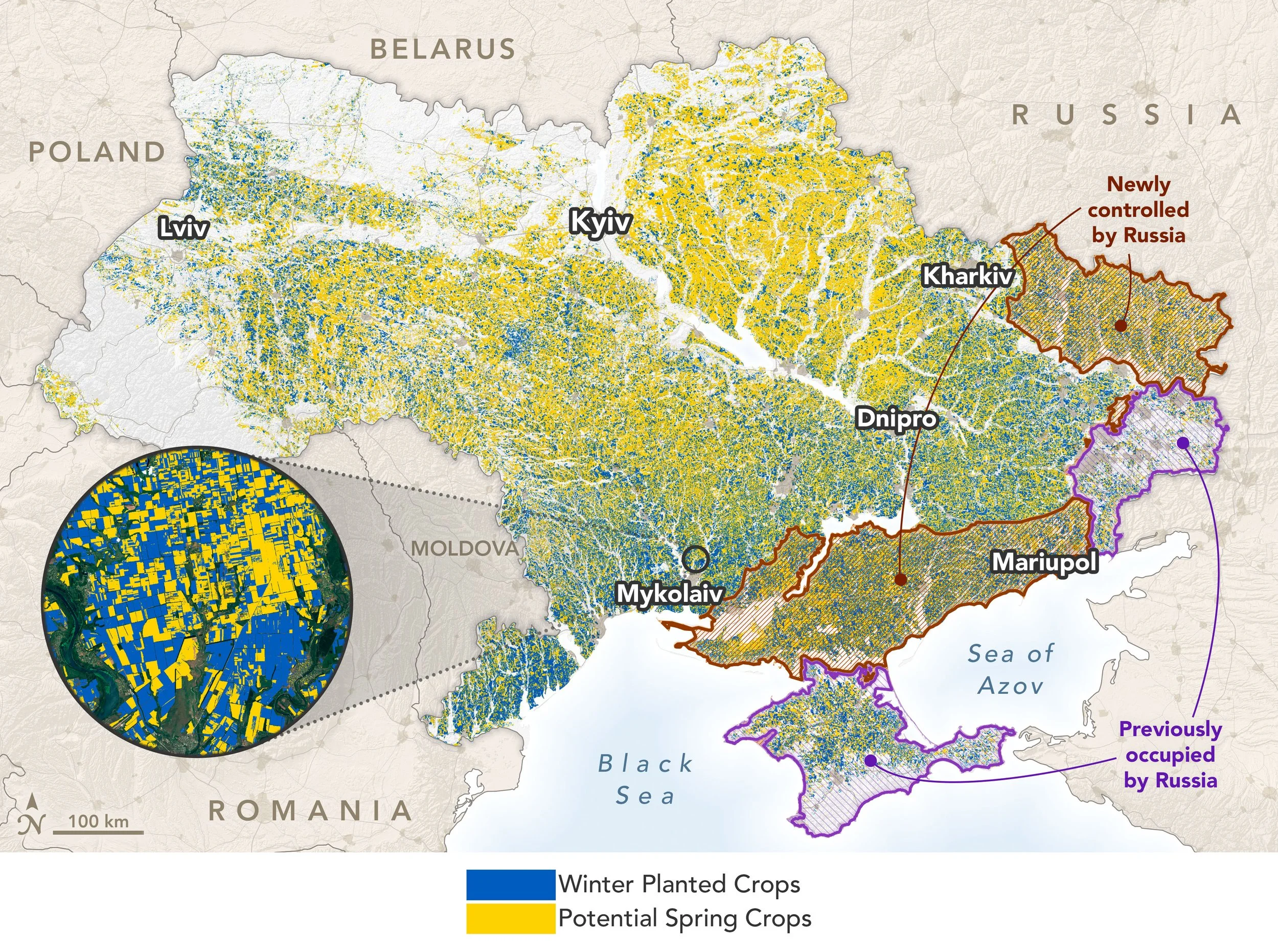
NASA Harvest mapped winter crops (blue) and potential spring crops (yellow) across Ukraine using Planet and Sentinel-2 satellite data. This June 13, 2022 map also shows areas under Russian control, giving researchers an early picture of where crops were growing as the war disrupted farming and agricultural reporting. Image c/o NASA Earth Observatory
The first step was figuring out where winter crops were growing. Researchers used satellite observations of how vegetation changed through the season to separate winter crops from other farmland. Winter cereals begin growing in the fall and become active again early in the spring, while rapeseed has its own seasonal pattern, including a distinctive flowering period. Those signals gave the team a way to map winter crops across Ukraine even where field observations were limited.
But mapping a crop is not the same as knowing how much land it covers. Satellite classifications can contain errors, so simply counting the pixels labelled as winter wheat or rapeseed can produce biased estimates. Instead, the team used the crop maps to guide a statistical sample of locations across Ukraine. Researchers then reviewed satellite imagery for those sampled areas to determine what was actually growing there. That approach allowed them to estimate planted area while also measuring the uncertainty around the estimates.
Knowing where winter crops were growing still didn’t answer the most urgent question in 2022: whether those crops were actually harvested. The team used the winter crop map as a starting point, then tracked changes in satellite imagery through the harvest season to identify fields where harvesting had taken place. A crop reaching the end of its growing cycle does not necessarily mean that it was harvested. By looking for the signal of the harvest itself, researchers could separate fields that had been harvested from those that had not.
What Changed From 2022 to 2025
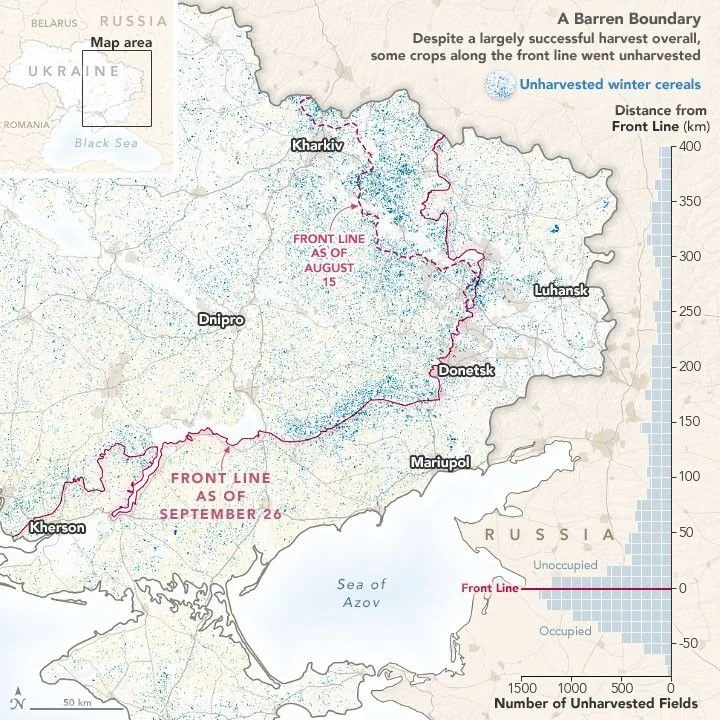
NASA Harvest’s 2022 analysis found that most of Ukraine’s winter crops were harvested despite the war, but unharvested winter cereals (blue) were concentrated near the front line (magenta). The map also shows how the front line shifted during the season, helping explain why some unharvested fields extended into areas that later returned to Ukrainian control. Image c/o NASA Earth Observatory
The results showed substantial disruption, but also more harvesting than many might have expected. Researchers estimated that 94.1% of planted winter crops were harvested in Government-controlled territory, compared with 87.5% of Russian-controlled areas. Unharvested fields were especially concentrated near the occupation boundary. Overall, however, most winter crops planted before the invasion were ultimately harvested.
One thing that stood out was that visible damage wasn’t a reliable guide to whether a field had been harvested,” said Shabarinath Nair, NASA Harvest’s South Asia Co-Lead. “Some damaged fields were harvested, while many unharvested fields had no obvious signs of shelling or burning. That made it important to detect the harvest itself.”
The monitoring effort continued beyond the 2022 harvest. In each of the next four growing seasons, NASA Harvest produced new winter crop maps and planted-area estimates for both Government-controlled and Russian-controlled territories. The framework evolved too, incorporating new satellite data and statistical methods while continuing to produce timely estimates of where winter crops were growing and how much land they covered.
The longer record showed a different pattern across Government-controlled and Russian-controlled territories. In Government-controlled areas, winter wheat planted area fell by about 9% from 2022 to 2023, then changed little over the next two seasons. Russian-controlled areas were more unstable. Winter wheat area declined again in 2023, then fell by roughly ⅓ in 2024 before partially recovering in 2025. In Government-controlled territories winter wheat areas stayed stable between 2025 and 2026 while they increased by 41% in Russian-held territories.
Rapeseed followed a different pattern, but the divide between the two areas was even clearer. In Government-controlled territory, planted area rose and fell from year to year, but remained substantial through 2026. In Russian-controlled areas, rapeseed planting dropped sharply, falling from 0.17 hectares in 2022 to just 0.03 million hectares in 2024. While trends indicate a slow recovery in 2025 and 2026, rapeseed areas remain negligeable in Russian-held territories. Those regional differences are easy to lose in a national total.
Supporting Ukraine’s Agricultural Statistics
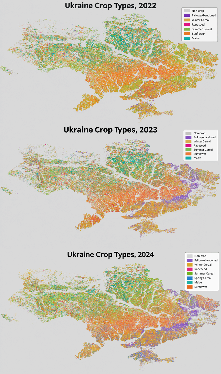
NASA Harvest crop-type maps show changes in Ukraine’s agricultural landscape from 2022 through 2024. The maps identify winter cereals, rapeseed, summer cereals, sunflower, maize, and fallow or abandoned cropland, allowing researchers to compare where crops were being grown across the first three growing seasons of the full-scale war.
For winter wheat, the satellite-based estimates generally lined up well with official statistics where those statistics were available. From 2022 through 2025, NASA Harvest's estimates of winter wheat area in Government-controlled territory were close to figures reported by the State Statistics Service of Ukraine (SSSU), with a difference of less than 5% each year. That agreement gave researchers greater confidence in estimates for Russian-controlled territories, where Ukrainian agricultural statistics were no longer available. The work was designed to complement Ukraine’s statistical system and extend monitoring into areas it could no longer reach.
“In Government-controlled areas, we had SSSU numbers to compare against,” said Josef Wagner, NASA Harvest’s Fertilizer Management & Environmental Health Co-Lead. “In Russian-controlled areas, that reporting wasn’t available, so remote sensing gave us a consistent way to apply the same framework across the country.”
The estimates were also being used while the research was underway. NASA Harvest delivered seasonal winter crop area estimates to the SSSU and the Food and Agriculture Organization of the United Nations (FAO). The work became part of a broader collaboration with the SSSU, the Ministry of Agrarian Policy and Food of Ukraine, FAO, and the European Bank for Reconstruction and Development to support crop area, yield, and production estimates during the war.
Taras Vysotskyi, First Deputy Minister of Agrarian Policy and Food of Ukraine, described the value of that information for agricultural policy, food security, and understanding Ukraine’s export potential:
“The timeliness, objectivity, and transparency of information remain essential factors in shaping a balanced and effective agrarian policy. We acknowledge and appreciate the vital role of NASA Harvest’s solutions and calculations in assessing the real state of agricultural production development in Ukraine, ensuring regional food security, and determining the export potential to support global food security.”
The approach still has limitations. Rapeseed proved harder to map consistently than winter wheat, while interpreting satellite imagery requires time and agricultural expertise. The 2022 harvest method was less accurate at identifying unharvested fields than harvested ones and cloud cover can also make it harder to determine whether a harvest took place. Even with those constraints, the work has provided a way to produce timely crop information across areas where traditional reporting and field surveys have been disrupted or are no longer possible.
Since 2022, this work has developed into a continuing framework for tracking winter agriculture across Ukraine, including areas where ground-based reporting is no longer available. With the war still disrupting farming and agricultural reporting, those satellite-based estimates provide another way to follow how Ukraine’s crop production is changing.
Read more about the methods and data behind our Ukraine work in the following articles: