Monitoring Crops from Space: How NASA Harvest Tracks Agriculture in Conflict Zones Like Tigray, Ethiopia
When war breaks out, it doesn’t just threaten lives, it disrupts entire communities, including their ability to grow food. In the Tigray region of northern Ethiopia, conflict between November 2020 and November 2022 created a humanitarian crisis that made it difficult, and often impossible, to collect information on food and farming through traditional methods. But thanks to the power of satellites and the work of scientists at NASA Harvest, we’re learning how agriculture is affected even when boots can’t be on the ground.
As part of the NASA Harvest consortium, researchers used Earth observation data to monitor the impact of the Tigrayan Civil War on local crop production. Two recent studies, led by Liya Weldegebriel and Hannah Kerner, show how satellite data can provide valuable insight into agricultural changes in the middle of conflict.
Liya Weldegebriel’s study, “Eyes in the Sky on Tigray, Ethiopia,” used Sentinel-2 satellite imagery and field observations to map “well-cultivated” land—fields that were in good condition and actively growing crops. Her team focused on highland areas, which are central to Tigray’s food supply. They found that between 2019 (pre-war) and 2021 (during the war), there was a net loss of about 543 square kilometers of well-cultivated land, especially in areas with more conflict and more displaced people.
“This kind of satellite monitoring can reveal where farming is struggling most and help guide aid to the right places,” said Weldegebriel. “In conflict zones, having eyes in the sky can mean the difference between food reaching those in need or not.”
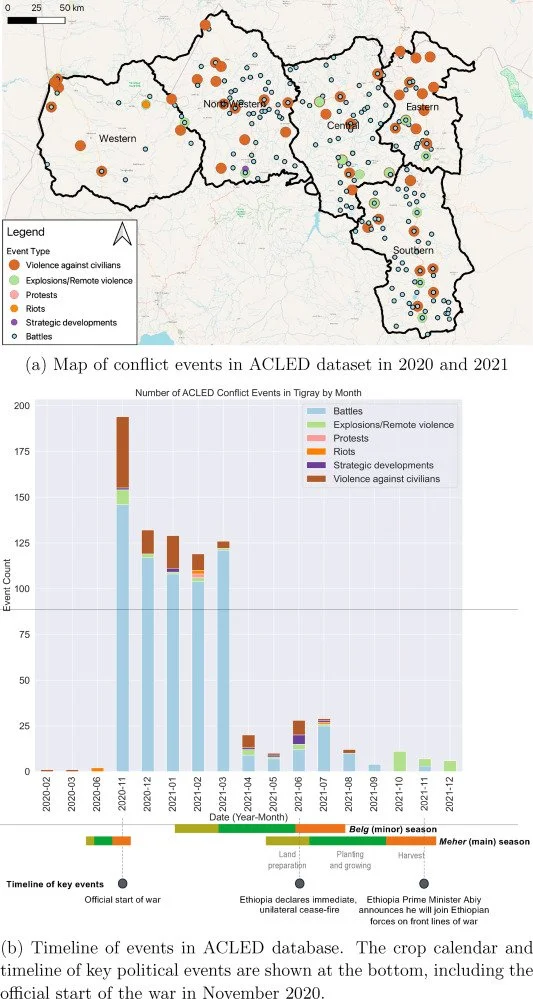
In another NASA Harvest study, “Satellite Data Shows Resilience of Tigrayan Farmers in Crop Cultivation During Civil War,” lead author Hannah Kerner and her team took a broader look across the entire region. They used machine learning and statistical models to estimate total cultivated land before and during the war. Their surprising finding? Despite the devastation of war, the overall amount of land being farmed remained largely stable. In fact, their data showed a possible slight increase in cultivated area from 1-1.26 million hectares in 2020 to 1.09-1.35 million hectares in 2021.
“What we saw in the data was resilience,” said Kerner. “Tigrayan farmers found ways to keep planting even in the face of conflict and hardship.”
Together, these studies show the power of Earth observation to uncover hidden information in places that can’t be reached by foot. While Weldegebriel’s research reveals significant losses in high-quality cropland, Kerner’s work shows that farming didn’t stop altogether. Many farmers adapted and continued to grow, often shifting where and how they planted.
Why does this matter? Because during war, understanding where food is—or isn’t—being grown helps humanitarian organizations know where to send aid. It helps policymakers plan better. And it ensures that even in the darkest times, science can still shine a light on what’s happening.
At NASA Harvest, we believe that no community should be invisible. With satellite data and the work of dedicated researchers, we can keep track of food production even in the most challenging places. By turning space-based technology into life-saving insights, NASA Harvest is helping feed the world, one pixel at a time.


