
Tracking Irrigation Loss in Southern Ukraine After the Kakhovka Dam Collapse
For decades, farming in southern Ukraine depended on water from the Kakhovka Dam. Its reservoir fed irrigation canals across the Kherson and Zaporizhzhia regions, supporting crops in an area with low rainfall. When the dam was destroyed in June 2023, that system failed almost overnight. What followed was not just flooding and infrastructure damage, but a lasting shift in how the land could be farmed.
A study by NASA Harvest’s Sheila Baber examined what happened next. Using satellite data, the research team measured how irrigation changed year by year and how farmers adapted when water was no longer available. The findings remain relevant because the effects are ongoing and because they show how agricultural production can be monitored after a major disruption, even then on-the-ground access is impossible.
The analysis relied heavily on high-resolution satellite imagery from Planet. These images made it possible to see individual fields, irrigation canals, and changes in crop condition across multiple growing seasons. By combining Planet data with other satellite sources, NASA Harvest compared irrigation patterns before the war, during the early years of conflict, and after the dam’s destruction.
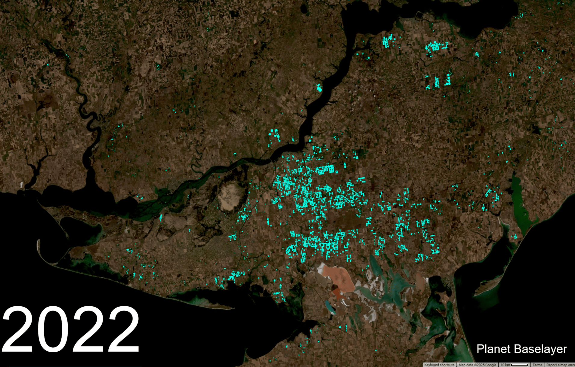
Changes in irrigated farmland in Southeastern Ukraine before and after the destruction of the Kakhovka Dam.
Before the full-scale invasion, irrigated farmland in Kherson and Zaporizhzhia averaged about 190,000 hectares each year. That number fell in 2022 as fighting expanded and access to fields became more limited. After the dam was destroyed in mid-2023, irrigation dropped sharply. Fields that had been watered earlier in the season lost access partway through the summer. By summer 2024, the study estimated that only approximately 16,000 hectares remained irrigated. That is a 90% decline from pre-war levels–and this is the trend seen in 2025 as well.
“The loss of the Kakhovka Reservoir produced rapid changes in the landscape. Within weeks of its loss in June 2023, once-irrigated fields were heating up and drying out. Some fields continued to stay green–but it did not necessarily mean that these fields were being irrigated. 2024 showed a dramatically different landscape where vast swaths of Kakhovka and Zaporizhzhia were left bare and dry–a pattern that continued into 2025. A few fields managed to still implement irrigation (a testament to Ukrainian farmer resilience), but at a scale that is not comparable to what existed before.”
The loss of irrigation forced farmers to make difficult choices. Summer crops like maize, sunflower, and vegetables became much harder to sustain. Many fields were left unused, while others shifted to winter crops such as wheat and barley, which require less water. This change reduced risk, but it also limited what farmers could grow and how much they could produce.
What makes this study particularly useful is not only the scale of irrigation loss it documented, but how that loss was measured. Much of the region is under occupation, making field surveys unsafe or impossible. Satellite data provided a consistent record of change, allowing researchers to track impacts long after the initial disaster.
The work by Baber and her co-authors at NASA Harvest shows how satellite monitoring can support decision-making after large-scale disruptions. It provides a clear picture of how damage to infrastructure translates into long-term changes in agricultural production. It also sets a precedent for how similar events can be assessed elsewhere.
The damage from the Kakhovka Dam collapse is not confined to a single season. It reshaped what farming looks like across a major agricultural region. Studies like this make those changes visible, measurable, and harder to ignore.