
Mapping Ukraine’s Fields from Space: A New Tool for Food Security
In times of crisis, accurate and up-to-date information becomes essential—especially when it comes to feeding people. A new study led by NASA Harvest and its partners answers a critical need for reliable agricultural data in Ukraine, a global breadbasket disrupted by war.
The study, titled National-Scale In-Season Field Boundaries of Ukraine Using Remote Sensing, introduces a powerful dataset of more than 5 million individual field boundaries across Ukraine, mapped using high-resolution satellite imagery. The work was co-authored by NASA Harvest scientists and collaborators, including Yuval Sadeh, a NASA Harvest researcher at the University of Maryland and Monash University.
"In a country where agriculture plays a vital role in both local and global food systems, having access to accurate, up-to-date field maps during an ongoing conflict can be the difference between reactive aid and proactive solutions," said Sadeh.
Ukraine is one of the world’s top producers of wheat, maize, and sunflower oil. Since the Russian invasion began in 2022, food production and exports from Ukraine have been under serious threat, raising concerns about global food security. With limited access to on-the-ground data—especially in conflict zones—satellite data has become a key tool for understanding what’s happening in real time.
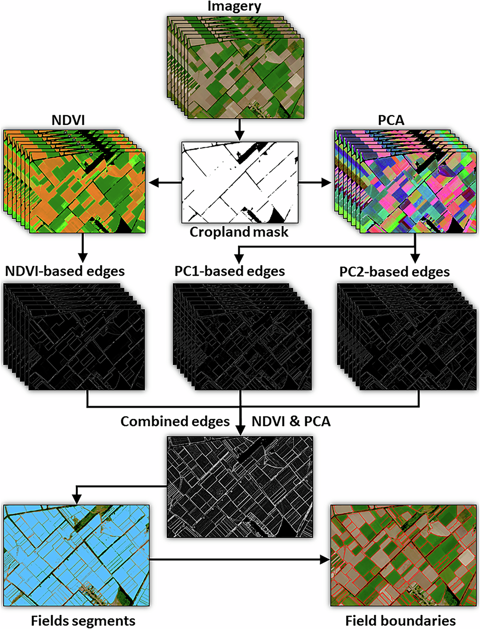
Illustration of the field boundaries delineation workflow.
To map the field boundaries, the team used Planet’s 3-meter PlanetScope satellite imagery taken every two weeks throughout the growing seasons. They looked for edges that showed up again and again over time, helping them spot where one field ends and another begins. Instead of using hard-to-get training data, they built a system that combined different layers, like vegetation indexes and the output of a principal component analysis. This allowed them to map more than 5 million fields across Ukraine quickly and accurately, even during difficult weather or war conditions.
The result is a dataset of field boundaries at the national scale for the years 2021 to 2023. This data has been validated against more than 12,000 real-world field records provided by Ukrainian farmers and agricultural companies. With an accuracy of 77%, the method proves to be both timely and reliable.
This dataset and the code is now publicly available through the NASA Harvest Data Portal, giving researchers, policymakers, and humanitarian organizations a vital resource to support food production analysis, recovery planning, and targeted aid. NASA Harvest hopes that by releasing the analysis source code, other users are able to implement the analysis in other areas of interest.
In a world where both weather shocks and human conflicts are disrupting agriculture, tools like this offer a way forward. By making high-quality data openly available, the NASA Harvest team and its partners are helping build a more resilient and informed food system—starting with the fields of Ukraine.